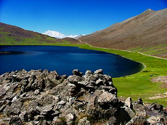
Shoesar Lake is located in Deosai Plains. Shio means blind and sar means lake. Deosai Plains are a vast area with hundreds of wild flower species. Deosai Plains are located at a height above 4000 meters and you won't find any trees or high bushes, except a carpet of flowers. In the background of this pic you can see Nanga Parbat (the Killer Mountain) as high as 8126 meters
Sunday, November 11, 2007
Saturday, November 10, 2007
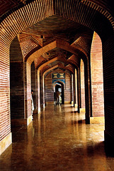
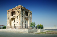
Umar Hayat Palace
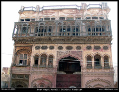
Umar Hayat Palace is a masterpiece of indigenous art and architecture, located in the centre of the city. If architecture is frozen musicm the Umar Hayad Palace in Chiniot is the creavity of human spirit, with its breathtakingly beautiful Jharokas(balconies)a-nd exquisitely engraved arches.It has a great attraction for local and foriegn tourists for its beauty.This beautiful four-storeyed palace is adorned with unique art work and is one of the most artistic buildings in the architectural history of the subcontinent.But Umar Hayat could not see and enjoy his masterpiece as he died in 1935 just before its completion.
Umar Hayat Haveli
Originally uploaded by wasilMembers of shaikh family migrated from Calcutta to Chiniot in the 18th or 19th century A.D. Sheikh Omar Hayat who was a successful trader born in a middle class family. He decided to construct a magnificent palace for his newborn son in 1923.
Syed Hassan Shah was assigned the task of palace's construction. He gathered many famous artisans from different places who continued working day and night for 10 ten years. Rahim Bakhsh Pirjha and Elahi Bakhsh Pirjha who were masters in manabat kari did wood carving. Gazeteer Vol XXXII, Jhang district 1929 states, "The house built by Sheikh Omar Hayat is a sort of local wonder, as it cost more than Rs 200,000 to make and rises high above all other buildings of area". The construction of the palace completed in 1935 and Mr Hayat expired in same year just a couple of months before its completion.
History claims that Mr Hayat's only son Gulzar Muhammad's marriage in 1938 brought an ironic twist of fate in the shape of death . He (Gulzar) was found dead in the palace the very next day of his marriage. The news of son’s death lofted loads of grief on mother who died remembering him. Both the mother and the son were buried in the courtyard of the ground floor of the palace.
Mr Hayat's relatives left the palace thinking it as a subject to bad luck, while servants continued living for a couple of years and then parted from it. An orphanage was established by some religious leaders and then it was evacued when its top story collapsed. Next came the Qabza groups who got shops and houses constructed on the piece of land lying next to it.

Originally uploaded by wasil
Syed Hassan Shah was assigned the task of palace's construction. He gathered many famous artisans from different places who continued working day and night for 10 ten years. Rahim Bakhsh Pirjha and Elahi Bakhsh Pirjha who were masters in manabat kari did wood carving. Gazeteer Vol XXXII, Jhang district 1929 states, "The house built by Sheikh Omar Hayat is a sort of local wonder, as it cost more than Rs 200,000 to make and rises high above all other buildings of area". The construction of the palace completed in 1935 and Mr Hayat expired in same year just a couple of months before its completion.
History claims that Mr Hayat's only son Gulzar Muhammad's marriage in 1938 brought an ironic twist of fate in the shape of death . He (Gulzar) was found dead in the palace the very next day of his marriage. The news of son’s death lofted loads of grief on mother who died remembering him. Both the mother and the son were buried in the courtyard of the ground floor of the palace.
Mr Hayat's relatives left the palace thinking it as a subject to bad luck, while servants continued living for a couple of years and then parted from it. An orphanage was established by some religious leaders and then it was evacued when its top story collapsed. Next came the Qabza groups who got shops and houses constructed on the piece of land lying next to it.
Monday, November 5, 2007
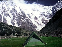
Bizin Camp, Nangaparbat
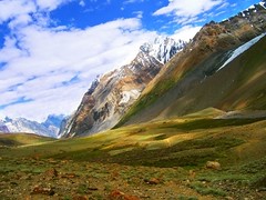
The Himalayas are a great mountain range. The central Himalayan mountains are situated in Nepal, while the eastern mountains extend to the borders of Bhutan and Sikkim. The Nanga Parbat massif is the western corner pillar of the Himalayas. It is an isolated range of peaks just springing up from nothing, and is surrounded by the rivers Indus and Astore. Nanga Parbat or "Nanga Parvata" means the naked mountain. Its original and appropriate name, however, is Diamir the king of the mountains.
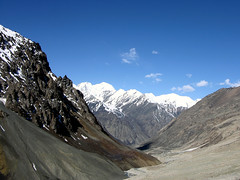
Nanga Parbat Base Camp
Nanga Parbat (main peak) has a height of 8126 meters/26,660 ft. It has three vast faces. The Rakhiot (Ra Kot) face is dominated by the north and south silver crags and silver plateau; the Diamir face is rocky in the beginning. It converts itself into ice fields around Nanga Parbat peak. The Rupal face is the highest precipice in the world. Reinhold Messner, a living legend in mountaineering from Italy, says that "every one who has ever stood at the foot of this face (4500 meters) up above the 'Tap Alpe', studied it or flown over it, could not help but have been amazed by its sheer size; it has become known as the highest rock and ice wall in the world!".
Nanga Parbat has always been associated with tragedies and tribulations until it was climbed in 1953. A lot of mountaineers have perished on Nanga Parbat since 1895. Even in recent years it has claimed a heavy toll of human lives of mountaineers, in search of adventure and thrill. Its victims, have included those in pursuit of new and absolutely un-climbed routes leading to its summit.
It was in 1841 that a huge rock-slide from the Nanga Parbat dammed the Indus river. This created a huge lake, 55 km long, like the present Tarbela lake down-stream. The flood of water that was released when the dam broke caused a rise of 80 ft in the river's 3 level at Attock and swept away an entire Sikh army. It was also in the middle of the nineteenth century that similar catastrophes were later caused by the damming of Hunza and Shyok rivers.
The Nanga Parbat peak was discovered in the nineteenth century by Europeans. The Schlagintweit brothers, who hailed from Munich (Germany) came in 1854 to Himalayas and drew a panoramic view which is the first known picture of Nanga Parbat. In 1857 one of them was murdered in Kashgar. The curse of Nanga Parbat had begun.
Sunday, November 4, 2007
The Roof of the World
Khunjerab Pass (el. 4693 m./15,397 ft.) is a high mountain pass on the northern border of Pakistan-administered Kashmir (Northern Areas of Pakistan) with the People's Republic of China. The name comes from the Wakhi for Blood Valley.
It is the highest paved border crossing in the world. It is also the highest point on the Karakoram Highway. This section of the road was completed in 1982, superseding two other passes (the Mintaka Pass and Kilik Pass - both unpaved) previously used by travellers.
The long flat pass is often snow-covered during the winter season and is closed from October 15 to May 1. There is excellent grazing on the Chinese side of the pass, and domesticated yaks and dzu (a cross between yaks and cows) may be seen from the road. On the Pakistani side, the highway travels about 50 km across the extensive Khunjerab National Park before reaching the security outpost of Dih. From there, it is another 35 km to the customs and immigration post at Sust.
Since June 1, 2006, there has been a daily bus service across the boundary from Gilgit, Pakistan to Kashghar, China and road widening work has begun on 600 kilometers of the highway.
In 2007, consultants were engaged to investigate the construction of a railway through this pass to connect China with Pakistan.
"If the doors of perception were cleansed every thing would appear as it is, infinite"
"If the doors of perception were cleansed every thing would appear as it is, infinite"
Originally uploaded by Umair Mohsin
On the south wing of the Mahfil khana stands the Jama Masjid or Shah Jahani Mosque, which is a fine piece of Moghul architecture. All the 99 sacred names of Allah with 33 Quranic verses are beautifully inscribed in the mosque.
Thatta's monuments include the Jama Mosque (also Shahjehani Mosque and Badshahi Mosque), built by Shah Jahan in 1647-49 and lined with glazed tiles. This edifice has 101 domes and is designed in such a way that imam's voice can reach every corner of this building without the help of any loudspeaker or other device.
There are also the tombs of Jam Nizamuddin, Satihoo Seven Soomro Sisters (reigned in 1461-1509), several Tarkhan rulers and Mughal officials. A vast old necropolis with thousands of graves may be found at the nearby Makli Hills.
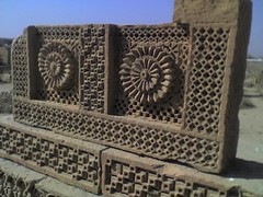
Design of a grave..at Chowkandi Tombs
Chowkandi tombs lie in the suburbs of Karachi, just adjacent to FAST university.
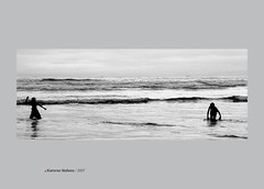
Karachi, seaview
Clifton Beach, on the Arabian Sea, is a beach in Clifton, Karachi, Sindh, Pakistan, one of the neighborhoods of Saddar Town, Karachi. The beach has attractions for families and tourists, including beachside horse and camel rides, amusement parks, restaurants, and swimming in the Arabian Sea.
The whole beach area of Clifton and Seaview is considered safe and peacful even in times of political turmoil.
A gated residential area called Seaview Apartments lies close to a section of Clifton beach known as Seaview beach or simply Seaview. Further ahead lies Darakhshan Villas which comprises of residential townhouses.
In this very area new CINEPLEX cinema houses were constructed for the entertainment starved people of Karachi, particularly for the people who reside in DHA and Clifton. This has happened after around three decades of cinema decline in Pakistan. Hollywood films are released here along with or soon after the international releases of these films. These cinemas are more expensive and are family cinemas meaning that no males or group of males are allowed to watch movies here without being accompanied by families, females or children.
Defence Housing Authority is filling the beach area with sand to obtain more ground and this will push the beach further, which will change the shape and features of this beach.
Other beaches close to the city include Sandspit, Hawke's Bay, and Paradise Point - a sandstone rock promontory with a natural arch, but Clifton Beach is the most popular picnic destination in Karachi.
Sky is the limit
Swinje Valley is one of the most beautiful valleys of Pakistan, that is not easily accessible for everyone.
Tomb of un-known dancer
Built by the side of tank is the tomb, Maqbra Hakiman which has its link with the period of Mughal Emperor Akbar the great.
The Maqbra Hakiman or the tomb of hakims (physicians/ wisemen) occupies the eastern portion of a large platform (suffa) measuring 38.5 meters by 20.7 meters. To the western side of the platform is a tank measuring 13.7 meters in length and 13.1 meters in width. Stone footsteps, from eastern as well as western side, lead down to the water level in the tank. The water oozes from its beds but, no clue is yet available as to where it drains out. It always keeps a uniform level. You can find a number of Mahasheer (a kind of fish) also present in the tank, which has been feeding here, in undisturbed peace throughout the ages.
Khwaja Shamsuddin Khawafi, a superintendent of construction in the times of Mughal Emperor Akber built this tomb while he was given charge to construct Attock Fort. Built with small sized bricks, which are covered with lime-plaster, the tomb is square in shape with each side measuring about 11 meters. The outer roof is flat while the inner is in the shape of a dome. Fresco paintings are used for the decoration. The plaster from most of the places is broken leaving Mughal bricks naked. Other tomb was also built by Khwaja for himself, as he wished to be buried here after his death.
Subscribe to:
Posts (Atom)
